2023 Update: Please note this trip took place in 2014 at a time when harmful human impacts were increasing along the Bluff Trail. Since that time, four dedicated and approved Leave No Trace (LNT) Educational Camping Sites were created. However, there is more to the story and our aim is not to encourage more camping in this area. For this reason, we have removed the map showing our route and campsites.
The Bluff Trail is a truly wonderful resource and we strongly encourage all trail users to become familiar with the Woodens River Watershed Environmental Organization and the Bluff Trail Stewardship Program. We also encourage anyone considering camping in this area to first review the Bluff Trail camping guidance.
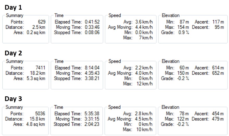
2 nights – November 21-23, 2014 (36.5km)
“Ah-Ha” Moment
The potential Otter Lake Landfill expansion was back in the news and we decided it was time to create an adventure in the Five Bridge Lakes Wilderness Area before the garbage pile takes over the views.
Theory
This was an epic three-day, two-night trip exploring the Birch Cove Lakes and Five Bridge Lakes wilderness areas. It was mostly an on-trail adventure. This trip was posted on Meetup (Halifax Adventure Seekers) to try and attract some new people, with a maximum of 8 people and 4 tents for a true wilderness backpacking experience.
Planning
We were planning a late fall weekend trip that didn’t interfere with work schedules. That meant 2 nights and three days, knowing that the first evening would need to be a short hike into the campsite after dark. The plan was bring people into some new areas by following existing but rarely used trails as much as possible, with a few short areas of bushwhacking to connect the trail systems.
We had a pretty good feel for the area from day hikes and quick over-nighters but now we needed to find campsites for the group and connect the two wilderness areas with minimal use of logging roads, power lines and developed areas. We also needed to avoid swimming, which was a real possibility with recent heavy rains and local area water release for dam repair. After four or five recon missions, we identified 5 possible campsites and most of the trail connections that we needed to find. Next came the hard part… scouring maps, apps and satellite images to find the best route connecting two of the campsites and key points of interest with hikes of the right length and difficulty without unnecessary backtracking.
Crew
We failed in our recruitment mission and started out with 7 more or less (un)usual suspects. We ended up with 6 and hot chocolate, but that’s a story for Day #2.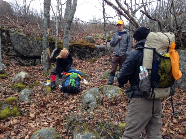
Day 1 – Cold, dark and getting windy
We set out from Anahid Drive in Hammonds Plains. It was a slow start as usual, since somebody always fails to watch the time. It was easy walking for the first 1.5km on a dry logging road, followed by a gradual climb of 75m over another 1km on the Blue Mountain Trail to the summit. The trailhead is marked with flagging tape covering a tree almost like tinsel, but it’s set back and you could easily walk past at night. The trail is pretty easy underfoot with two small log bridges at the beginning and one or two rocks large enough for scrambling. There are some neat city views from the top of Blue Mountain, but it was windy and colder than the forecast, at -5°C with gusts to 60km/hr. Camping on the flat rocky summit made for a loud chilly night.

Day 2 – Cold, sunny and substantially windier
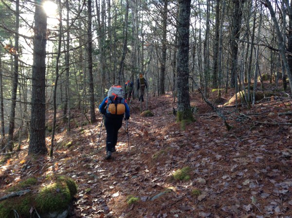
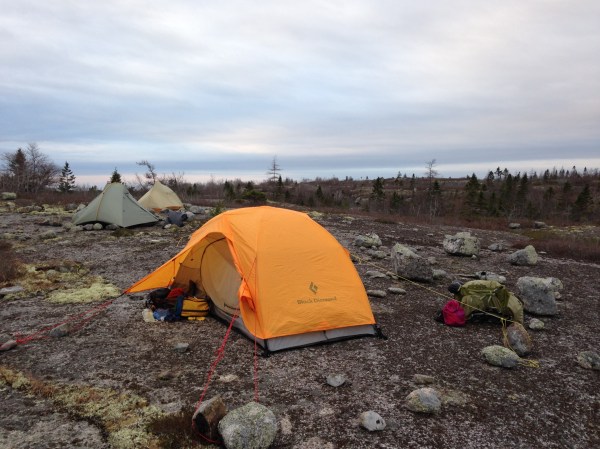
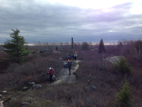
Nobody was in a hurry to get out of their warm tents, but we were only 25 minutes behind schedule which is pretty good considering 7 people and 7 morning routines. We set out following animal trails down off the summit into open forest for a short bushwhack to the power line, then a second bushwhack down to the trail along the west side of Ash Lake. This relatively unused trail passes through areas of beautiful mature trees including one very short detour to the lake’s edge at a canoe lunch spot with a huge old hemlock. The open forest and aging flagging tape does require some attention to stay on trail. At the south end of Ash Lake we took another famous “abrupt right turn” off the trail in search of the remains of an old cabin at Crane Lake. From there we plowed through boggy forest to cross the beaver dam and join the Susies Lake trail system. The bushwhacking went well and we were ahead of schedule. Unfortunately one hiker tweaked a previously injured knee just before lunch. She was tempted to continue with a knee brace and trekking poles, but made the wise decision to be better safe than sorry. Conveniently the closest bail point was actually along our route about an hour ahead and she was able to walk without too much discomfort. So that’s how we came to meet her boyfriend at our only planned road crossing and trade hiker #7 for a round of hot chocolate! After that it was a brief stint on the wide gravel BLT Trail to the entrance of the Bluff Trail System in the Five Bridge Lakes Wilderness Area. It’s a series of 4 stacked loops, and we were planning to camp at the beginning of the second loop in an area where we knew there was open rock for minimal impact. We have hiked this area many times before and noted on this occasion many more signs of overuse including fire pits and garbage along the trail. The camping site is quite exposed and it was another windy night, though nowhere near as cold as the night before. After supper people retreated to their tents with some shouting between tents to keep the conversation going.
Day 3 – Cold, cloudy and still a bit windy
By group consensus over breakfast we decided that instead of completing all four loops, we would shorten the third day by about 4.5km and cross over at the third loop which none of us had done before. This turned out to be a great idea. The third loop connector trail was an unexpected treat with 2.6km of rolling hills, a few spectacular views, some mature tree stands, and a lovely sheltered lunch spot just out of the wind. After lunch the only remaining challenge was to find the place where a small foot trail departs the main Bluff trail along the west side of Cranberry Lake. That only took a few minutes, and all in all it was a lovely walk back out to where we had left a car parked along the BLT trail at Fraser Road in Timberlea.
High / Low
I think everyone was a bit surprised with the cold first night, and the obvious low was losing a hiker on Day 2. But overall the trip was a success — a two-night almost entirely wilderness hiking and backpacking experience right in the city and along major bus routes. Even better, nobody ended up in the water on any of the river crossings, not even the icy beaver dam.
Stats