

Partial Pemi Loop+, White Mountain National Forest
July 16-21, 2016
Over the winter we’d talked about trying to plan some harder trips this summer, both in terms of length and terrain. Near the top of the list was traversing the Appalachian Trail from New Hampshire to Maine through the Mahoosuc Notch. However, Wade had an unfortunate leg injury in the spring and we decided that we should go with something more moderate.
We’d loved our trip around the Pemi Loop in 2015, especially with perfect weather along the Franconia Ridge, but we had largely missed out on views over the Bonds. We decided to head back to the area and pick off a few more 4000 footers that we’d missed the first time around.
This was a relatively last-minute trip waiting on the healing leg, and we wanted to build in maximum flexibility to get views on the Bonds. We plotted the route between Liberty Spring and Hale Brook trailheads in both directions, with multiple options for where we would camp. Tentsites in the White Mountains are first come first served, and we knew there would be a plenty of AT through hikers, section hikers, and weekend/day hikers in the area. We were somewhat hesitant to return to such a popular place on a busy July weekend, but the timing worked and we figured that with some flexibility we’d be ok.
After reviewing weather predictions, we decided to start at Liberty Spring. We were originally planning to stay in one of the US Forest Service campgrounds the night before to get an early Sunday morning start, but they were all booked and the private options that we found required multiple-night stays on summer weekends, so we decided to drive straight to the Whites and start hiking Saturday afternoon.
We’d had great luck with Notch Taxi for last minute reservations in the past, but this time he was booked up. Luckily, he connected us with another shuttle driver who could meet us at the Hale Brook trailhead for the 30 minute drive around to Liberty Spring. There was a brief moment of panic enroute to meet the driver as we realized we’d forgotten to buy a White Mountain National Forest Recreation Pass (which are required to leave a car in the parking lot for multiple days) before leaving Gorham, but luckily we were able to pick one up at the Living Waters Campground office which was basically on the way.
Though we knew we were arriving in peak season, we were still quite impressed and somewhat disheartened to see the sheer volume of cars parked along the road as we passed each trailhead. We were thankful we had easily found parking back at Hale Brook. It was a long hectic day, but we found ourselves standing at the Liberty Spring trailhead ready to head up the hill around 5pm.
Day 1: Liberty Spring Trailhead to Liberty Spring Tentsite… and beyond
6.6km, 3:30 (moving 1:59), Gain 974m, Loss 167m
Despite it being the early evening when we set out, once we headed up it was a hot climb with no real breaks along the trail.

After the long drive from Nova Scotia, we were pretty tired. We passed quite a bit of traffic on the trail, and were wondering if there would be any space at the Liberty Spring tentsite when we arrived. We knew that they do their best to accommodate groups, and that they have overflow sites, but weren’t sure what to expect when we arrived. What we found was a swarming mass of campers, barking dogs, and a collection of fellow hikers who had just been told the sites were all full. And it definitely was full — multiple tents sharing pads, a few pitched on rocky surfaces around the caretaker’s tent, and at least 5 set up in the cooking area. There was even a lineup for water. We found a spot to put our packs and enjoyed a break while we pondered our next move. The rules for “stealth camping” are quite clear, but with so many other groups looking to do the same thing we weren’t sure if we’d be able to find a place spot far enough along the trail. We are very familiar with the so-called “stealth” sites that are visible along both sides of the trails in well travelled areas, particularly along the Appalachian trail where we’d be spending the night. We did not want to contribute to the degradation of those sites which are clearly in violation of the White Mountain’s backcountry camping rules. We eventually decided to head, “up and left” (towards the Franconia Ridge) and see what we could find.
After exploring off trail in a few places where the terrain looked relatively flat (remember we were travelling along the beginning of the ridge at this point) we discovered that most of the illegal tent sites along the trail had other less visible sites in behind them. Just before dusk we found a flat-ish spot just large enough for the tent which was at least very close to 200’ off trail, and definitely not visible from the trail. We’d had a late afternoon meal in lieu of a full supper, so we just snacked on protein bars as we set up camp. We were tired and fell asleep quickly.
Day 2: Somewhere beyond Liberty Springs tentsite to Garfield Ridge
10.7km, 8:42 (moving 3:47), Gain 882m, Loss 914m
We set out early. The morning started off cool and misty. At times the mist was thick enough to feel like rain, though the precipitation would come and go quickly.
We passed some of the other groups of hikers still camped out along the trail in various degrees of violation of the camping policies. The worst example was a hiker sleeping in his hammock a few feet off the trail with a large pile of clearly used toilet paper right at the edge of the trail. It is infuriating to see people show such little respect.
Our first traverse of the Franconia Ridge the year before was on a bright sunny day. This time was completely different, but no less spectacular. It started out with clouds billowing up and over the ridge, and pooling in a thick white mass just behind the ridge.


The wind picked up and the sky gradually cleared as we crossed.

When we reached the Skookumchuk trailhead, we decided to stop and try to dry out the tent a bit in the wind. The tent is red and white and we didn’t think about how this would look from a distance until a family reached us and commented, “Now we can see what you are doing. We thought you were pitching a Canadian flag.”
We remembered the stretch from Skookumchuk to Garfield being rough, but we took our time and reached the peak just in time for bright sunlight. We stopped for a relaxing late lunch surrounded by other groups of hikers. Eventually we made our way to the nearby Garfield Ridge campsite to get set up for night #2.

Day 3: Garfield Ridge to 13 Falls
4.4k26, 2:16 (moving 1:26), Gain 28m, Loss 581m
This would be one of our shortest days of hiking ever. Oddly, the fairly easy downhill hike (after the initial decent from Garfield Ridge) was also the only time in the Whites that we hiked slower than the “book time.” Luckily it didn’t matter and we arrived nice and early at 13 Falls. We were expecting a lot of rain and possible thunderstorms, so we set up camp quickly.

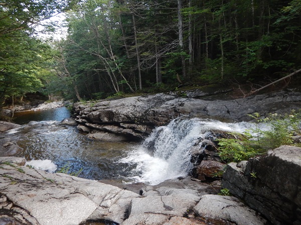
The sky remained clear for a bit longer so we headed over to check out the falls. We even made it in the water for a few minutes before the rain started.
It was an entertaining evening. Early on there was a group of 6 who arrived only to immediately turn back around once they realized it wasn’t the kind of campsite they were expecting. I think the “no campfire” rule was the final straw, though I think they were also having trouble finding a site large enough for their 6-person tent! Shortly after they left (at least one with a huge sleeping bag strapped loosely to the outside of his pack) the skies absolutely opened up in the hardest sustained rain shower we’ve experienced. We were settled in our rain gear under the leaky cooking shelter so stayed relatively dry as we watched the trails flood and the water stream around us. We exchanged stories with other hikers for a few hours before crawling into the tent to get some sleep.
Day 4: 13 Falls to Guyot (via North Twin)
13.6km, 7:48 (moving 4:36), Gain 1354m, Loss 816m
The plan for today was to pick off North Twin which we’d skipped on last year’s Pemi Loop. The climb up from 13 Falls wasn’t bad and we treated ourselves to a long break and many pieces of mint chocolate cake at the Galehead Hut before the rough climb up to South Twin. The jaunt over to North Twin was actually easier than we were expecting for some reason, and after a quick snack, we turn around and headed back to South Twin and on to Guyot.


The rest of the hike to Guyot was a repeat of our route the year before. There were some great clouds along the way.

When we arrived at Guyot it wasn’t too busy but we were warned by the caretaker that she might have to send another tent over to our pad if it got too busy.

Our small 2-person tent took up exactly half the pad (with one vestibule hanging over the edge, so were very surprised when she sent a 4-person group over to set up on the other half. It was one of the local camps with a group of adolescent teens. We collapsed our other vestibule and I guess they did all right with their feet hanging off the end of the tent pad…
Day 5: Guyot to just below Mt Hale (via Bondcliff)
17.9km, 9:47 (moving 6:02), Gain 1344m, Loss 1381m
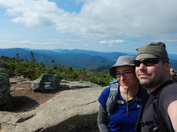
We were planning another relaxing day, with a trip over to the Bonds and back for a second night at Guyot. We had a leisurely breakfast then loaded up our packs with just enough for a day hike and headed out. The views from Mt Bond were incredible on this day.

So were the views along the ridge over to Bondcliff which was buried in thick fog on our last traverse.

 Somewhere near the peak of Bondcliff we both realized we were thinking the same thing… rather than stay the second night at Guyot we should push on toward Hale Brook to get a head start on the next day. We figured we’d be able to find a suitable stealth site somewhere given our previous success.
So, we headed back to Guyot for a quick lunch, packed up our gear and headed out for the second time, now wishing that we hadn’t had quite such a leisurely morning.

Once we were back on the AT there were quite a few through-hikers, including one couple from Georgia that we passed a few times as we detoured over to Zealand mountain and then later stopped for a snack break at a scenic viewpoint.


We quickly realized that it wasn’t going to be easy to find a campsite. What started out as a short day turned into a whole lot more. As we grew closer to Zealand Hut we decided out best bet would be to head to the hut and ask for a recommendation. We were tired! and the long downhill approach to the hut took just about everything out of us. The hut was stuffed to the rafters with a reunion of former AMC Hut Croo members and the baked goods were gone so we grabbed a handful of chocolate bars and studied the AMC White Mountain Guide for clues to where we might find a level spot for the tent. We knew it was all uphill from the Hut to the summit and we really weren’t looking to hike much further. We got tips from some of the reunion attendees and set out. We passed the first few potential sites we saw since we felt they were too close to the hut and then regretted that decision as we climbed further and further passing slopes, marshes, and little else. The entire first plateau was one large marsh, despite what we’d been told at the hut. Fueled by chocolate we kept climbing and finally found a spot we figured was very close to the summit just before dusk. We set up camp and had one of the best meals we’d ever eaten (it’s amazing how good things taste after a hard day of hiking!) as the full moon was rising.

We fell into a sound sleep and were woken by voices. Two hikers were chatting loudly as they made their way down from the moonlit summit. From inside the tent we watched their headlamps pass fade away into the distance, completely unaware of our presence.
Day 6: Just below Mt Hale to the Hale Brook Trailhead
3.2km, 1:24 (moving 1:05), Gain 12m, Loss 723m
We knew we were close to the summit but weren’t sure quite how close until we popped out up on top after only a few minutes of hiking in the morning.

We stopped for a few photos on the huge cairn and from there it was a relatively quick downhill push to the car. After two long days of hiking it was still rough on the legs, and we were pleased to reach the parking lot by 8:15am.

From there it was search for brunch as we headed back toward the border. Another successful trip in the White Mountain National Forest… we’ll be back!
