

Backpacking June 6-9, 2015, 3 nights, 53.8km
This trip was our “warmup for the Whites”. We had a few days free before heading to New Hampshire for some hiking in the White Mountains and wanted to try out a few new gear setups and get a few hills under our belt before the big trip. Cape Chignecto Provincial Park is primarily a wilderness park located near Advocate Harbour, NS, with a trail circuit that includes dozens of kilometers of coastline along the Bay of Fundy. The Bay of Fundy is considered one of Canada’s National Wonders, with the highest tides in the world and spectacular shoreline views of both Nova Scotia and New Brunswick. The trails in the park are quite hilly (for Nova Scotia), with trails rising up and down from water crossings at sea level to the tops of cliffs 180m over the ocean. With seven campsites dotted along the coastline and the opportunity to travel the loop clockwise or counter-clockwise, the park offers a ton of variety. You can either plan a leisurely trip with ample time to sit and watch the rising and falling tides (we’d highly recommend everyone do this at least once!), or push yourself with longer days to increase your stamina and tolerance for going up and down hills. There are also some new backcountry cabins as well as nearby kayak tours that can guide you along the shoreline for a completely different vantage point, but we haven’t done those yet.
We had each been to the park four times before this trip, but were curious about the somewhat mysterious McGahey Canyon Trail. We thought it could be a way to add a few more hills and some distance to our traditional park loop, but the official documentation doesn’t really say much about it. We knew that the trail starts out fairly close to the Red Rocks visitor centre and passes the New Yarmouth Campground, which is located inland with 28 walk-in sites. Park staff had told us it was approximately 4km from the visitor centre to the campsite, and since we’d be starting in the evening, this seemed like the perfect trip to check it out.
Food
We were also trying out some new meals on this trip. We make most of our own meals from a combination of shelf-stable products and foods that we dehydrate and package ourselves. This time we remembered to take a photo before we left. The foods below would be supplemented with some fresh fruit and vegetables from the Masstown Market, which is our traditional stopping-point on the drive to the park.

Breakfasts: couscous with bacon / granola with powdered milk and dried fruit / cream of wheat with dried fruit
Lunches: hummus, tabouli, Triscuits, cheese and beef jerky / chicken and cheese wraps / nut butter wraps
Suppers: ground beef with peas, carrots, mashed potatoes, spices / ground pork with macaroni and alfredo sauce
Extras: instant cappuccino (an experiment), olive oil, candy, Montreal Steak Spice, lemon crystals for lemonade, teabags
We pack snacks individually, generally 4 per person per day (2 morning and 2 afternoon), depending on the difficulty and length of the days. We didn’t take photos of our snacks this time, but they include things like raisins/peanuts, pretzels, Clif bars, cashews, beef jerky, Babybel cheese, dried fruit, sesame snacks, jelly beans….
Day 1: Red Rocks to New Yarmouth Campground (2.7km, 30min, Gain +239m, Loss-39m)
The blackflies were ferocious as soon as we opened the car door at the visitor centre around 6pm. The check-in was fast, with minimal discussion once we said that we had been to the park many times before. We asked about bears and they said there had been recent sightings at both Refugee Cove and along the McGahey Canyon trail. We know that bears frequent the park and are often seen at Refugee Cove (including on our last trip), so this was not a surprise. We did our final preparations and set out as quickly as possible, hoping the flies would calm down once we were moving. We had thankfully thought to bring bug head nets and jackets with us.

The McGahey Canyon Trail turned out to be quite lovely, with open forests and lots of ferns. We had been told that park staff had recently walked the trail to bring it up to provincial park standards.

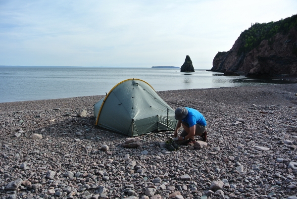
We were surprised to reach the campground cutoff so soon – turns out it was only 2.7km. There were piles of fresh gravel suggesting that maintenance was ongoing during the weekdays, but there were no signs of any other campers when we arrived. We set up the tent quickly and found a tree suitable for a bear hang nearby.


We were glad to have already eaten supper so that we could jump into the tent early to escape the bugs. Thankfully, the bugs weren’t much bother once we reached the coastal portion of the trip.
Day 2: New Yarmouth Campground to Refugee Cove (14.3km, 5:15, Gain +723m, Loss -923m)
The second part of the McGahey Canyon trail was mostly more beautiful forest. We didn’t see any evidence of bears, though it certainly seemed like prime terrain.

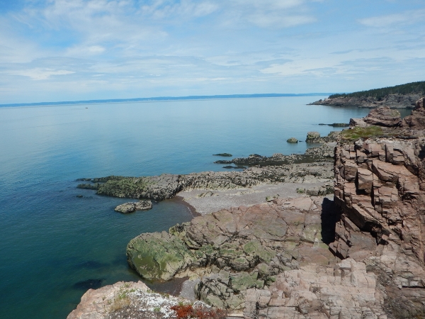
The trail rejoins the main coastal route just above the McGahey beach access point, at the bottom of a steep climb. This is where the coastal views start, and we definitely had some great views in the sunshine this trip.


We took a hidden detour down to a great waterfall site for lunch. The trail to this point was closed some years ago, presumably because people were using the point as beach access for a shortcut back to Red Rocks despite clear signage indicating that the area is impassable when the tide comes in.

After this point the trail passes through some of the most spectacular hardwood stands along the route.

We knew we were close to the Arch Gulch cabin, which is the first of three that we would pass. We were chatting about how we might incorporate the cabins into a future trip. As we approached the cabin we saw the outhouse (which is located right along the main trail) and then…

An old schoolyard garbage can… a steel barrel with a loose wooden lid. We stared at each other… were we really seeing a garbage can deliberately placed in the backcountry?? Apparently so. This one was half full of empty Mountain House food bags and chocolate wrappers, with discarded black latex gloves on the top. We could only presume these had been used by park staff to clean the outhouse. Incredibly, the can appeared undisturbed by animals.
As an aside… When we arrived back at the visitor centre, we were told that garbage cans are being placed at each cabin and that they are emptied after groups check out based on a “Provincial Park standard.” Staff said there were no problems with animals getting into that garbage can, though they agreed it is located near an area of frequent bear activity. They had no response to our question of why a garbage can would be required for a cabin that is supposed to be “pack-in-pack-out” or to the old adage that, “a fed bear is a dead bear”. After the trip we were able to speak to a representative from the Department of Natural Resources who shared our concerns. Hopefully the garbage cans will be short-lived!
There were no other bookings for that night at Refugee Cove and so we decided to camp on the beach. It’s a great spot to watch the Fundy tide come and go. It was interesting to see how different the beach looked this time. A storm had obviously done some pretty significant rearranging of the rocks since our last visit.

Day 3: Refugee Cove to Seal Cove (17.6km, 9:13, Gain +986m, Loss -974m)
It was a lovely clear morning to wake up on the beach.

We were planning on a long day because there are so many places to stop and admire the views.

The weather was great and we were counting on a lot of photo breaks. We ended up taking detours to almost all of the scenic look offs. At one point we heard noises in the distance… Wade recognized them as seals, and we eventually spotted them in a nearby cove. They are always fun to watch for a bit. We again admired all of the “hidden” coves and thought about finding the time for a guided kayak tour in the area.


Approaching Little Bald Rock campground, with views of the beach area.

After Little Bald Rock campground we came across this tree, or at least the parts of a tree that an over-zealous woodpecker left behind…. Impressive work!

There are some pretty impressive cliffs dropping down to reveal beaches when the tide is out.
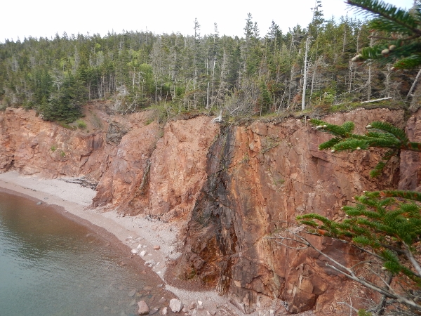

In other places sheer cliffs rise up to the trail.

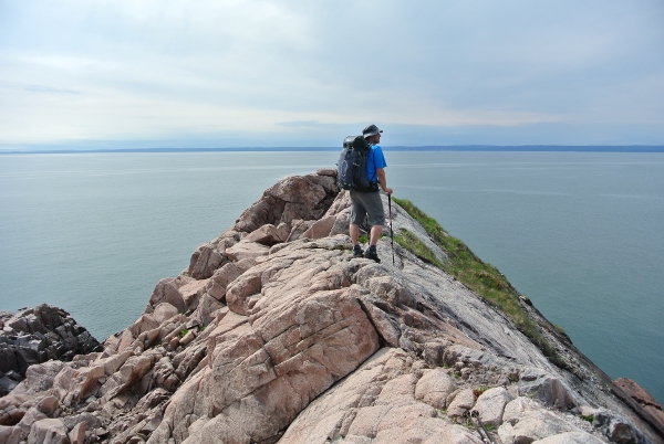
The terrain changes frequently along this portion of the trail.

Again, checking out the viewpoints.
Another “hidden” cove.

View of Carey Brook from the top of the steep descent.


We checked out two of the three cabins on this trip, and also walked through most of the campsites. It definitely seems like the park is focussing its efforts on the cabins rather than the campsites, and we wondered if this had anything to do with the recent acquisition of new lands in the centre of the park. It’s a shame that the cabins are not available for winter use, given that they have stoves and supplies of dry wood. There are ATV trails into each cabin for park staff maintenance, and these would make great skiing or snowshoeing routes in the winter. We observed that the access routes are being built up in some places, and wondered if this was in preparation for some sort of public vehicle access. That would definitely detract from the wilderness experience.
The wind was picking up when we arrived in Seal Cove and there were a few raindrops, though the forecast was clear.

We thought about pitching on the beach again, but big rocks suitable for anchoring the tent were too scattered and we thought the campsite would provide better protection from the wind. Since we were the only ones there, we set up in our site and used an adjacent site for cooking. A quick supper and bear hang, and then we settled into the tent for the night. We were glad to have chosen the woods. The wind on the beach must have been fierce, based on the whistling trees overhead.
Day 4: Seal Cove to Red Rocks (19.2km, 7:17, Gain +902m, Loss -928m)
It was still windy in the morning, though it was clearing with no further threats of rain.

No sign of rain clouds this morning!

After leaving Seal Cove, we again stopped to check out each viewpoint and enjoy the changing terrain along the way.


We had a great view of the “Three Sisters” sea stacks on this trip. We’ve always discussed doing the hike out from the Eatonville Day Use area to see them up close, but have never taken the time.

We were curious to see how the trail would look beyond Eatonville. Our last trip consisted of climbing over and around multiple huge deadfalls, some large enough that you completely lost sight of the trail and trail markers. The blowdowns were from a recent storm, and park staff at the time had told us they were aware of the mess and would be heading out the following week to clear the trails. We were pleasantly surprised when we reached the areas of deadfall; they had been cleared so well that you wouldn’t have known they were ever there. It was even hard for us to identify a few of the places. Good work by park staff on those!
The walk through the woods is always pleasant along the brook, and the flies weren’t too bad which was a nice bonus.

On top of the hill we again saw evidence of very recent bear activity, with signs of scratching for grubs and piles of scat. This was the third trip in a row that we saw fresh evidence of bears travelling along this section of path in this area.
The inland trail rejoins the main trail just before the last climb up these steps which lead to the steps back down to the beach. Such are the joys of coastal hiking….

But the view coming down the last long staircase was spectacular!

We finished this trip with a walk along the beach from McGahey Brook back to Red Rocks. This route is not passable at high tide, and tides vary by about an hour each day, so it is critical that you know the tide schedule before venturing out.

Almost back! Just the short walk from Red Rocks back up to the visitor centre…

High/Low
Overall this was a pretty quiet trip which we enjoy (and not surprising for a mostly weekday trip in June). We saw one group of 4 heading out of the park on our first day, and one solitary beach-walker near Red Rocks on our way out. That said, there were quite a few cars in the parking lot on Sunday afternoon when we arrived. We have done this trip a few different ways now in a variety of conditions, and these were the sunniest days with the clearest views yet. We never get tired of watching the Fundy tides.
The biggest “low” was seeing the garbage can placed in the backcountry, along with a general deterioration of some of the the campsites. We have noticed some significant changes since the province officially took over management of the park two years ago, and are planning to follow-up about some of our observations. We are curious to learn more about the nature of the transition from the “Friends of Chignecto” group and the province’s plans for the park. It is currently the only provincially operated backpacking route in the province, and it is unfortunate to see that it is significantly underutilized despite the fact that it has truly world class scenery and the potential to be a huge year-round draw.
We’ll definitely be back!

Looks nice. I must get there one day.
LikeLike
Thanks. It’s an amazing place and there are a wide variety of options all the way up from from short dayhikes. It’s definitely worth the trip!
LikeLike
Reblogged this on fooddrinknaturetravel and commented:
The joys of the Nova Scotia coastline.
LikeLike
Hi, nice article. I was wondering how long is the hike from refugee cove to big bald rock? Also is the trail very well marked, such that you do not need maps other than the generic one from the website?
LikeLike
Hi Zachary. The park gives a distance of 9km. 3-4 hours, at a decent pace. There are lots of great views along the way. In terms of maps, the park will give you a generic trail map when you arrive. We always bring a topo in case of emergency, though most people probably don’t in this park, even for their first time. The trails are well travelled and marked. If you have any more questions, don’t hesitate to email misadventuresinthewild@gmail.com.
LikeLike
This comment is for the authors – hopefully you will read this and respond.
This was really helpful – we are planning this trip the the first weekend in June this year.
It was recommended for us to do the trip backwards – through the forest first up to Eatonville, then along the coastal route back. Thoughts/ distances and recommend distance per day going this way? we are arriving on the Thursday evening and need to be back by Sunday afternoon/early evening.
also can you tell me what your gear list was and your overall pack weight? This is a first for us and we are getting too many conflicting opinions from folks who have only done it once. We are using it as a prep for the Fundy Footpath… Sounds like you know what you’re doing!!
LikeLike
Hi Marguerite. Thanks for the note. The park is great in either direction. If you are arriving Thursday evening and heading CCW, you could stay at Christie Field the first night, hike to Seal Cove Friday, around to Refugee Cove Saturday, then out to Red Rocks Sunday. That’s roughly 20km, 20km, 12km with spectacular views each day. Just one of many options. In terms of gear, we’re fairly lightweight, which makes the hills easier. Our packs are typically around 17lbs starting weight. On this particular trip Wade’s pack was 24lbs because we were trying out some different gear. Happy to share more info by email at misadventuresinthewild@gmail.com.
LikeLike
We are planning this trip for late June. Just wondering exactly what your pack list was, the above seems light …can you advise. I am always looking for ways to lighten up the load. 😉 . Great food ideas.
LikeLike
Our gear has changed over the years. Here is a link to Wade’s solo gear list for a normal three or four day trip. https://lighterpack.com/r/3cuean When we’re together the only real change is 1/2 of a Hubba Hubba instead of the single tent. We’ll also often have a GPS and PLB depending on location. Feel free to email if you’d like to chat more.
LikeLike